We would like to take this opportunity to welcome you to Wayfarer’s Horizon, the premier site for camping, trekking, and backpacking excursions on the island of Madeira! Today, we are overjoyed to extend an invitation to you to join us on a five-day trekking trip to Madeira. This excursion will provide you with an unparalleled combination of magnificent scenery and challenging difficulties, making it ideal for both avid backpackers and trekkers.
We start our tour in the picturesque coastal village of Porto Moniz, which is well-known for the natural lava pools and the rustic charm that it possesses. Prepare yourself to traverse deep forests, mount mist-veiled summits, and maneuver the spectacular cliffs that define the rough beauty of Madeira as we are about to embark on this backpacking experience in Madeira. Every day will consist of more than 20 kilometers of hiking and more than 1,500 meters of climbing, which will put even the most experienced backpackers and trekkers to the test.
Those individuals who take pleasure in the strenuous adventure of camping and backpacking, taking pride in the perspiration on their forehead and the dirt on their boots, are the ideal candidates for this Madeira trekking experience. Because of the difficulty of the route, participants are required to be in excellent physical shape and be prepared to travel long distances while carrying a rucksack that weighs fifteen kilograms. This Madeira camping and hiking journey will push you to new heights and reward you with moments that you will never forget. It is a true test of endurance.
We will arrive in Santa Cruz, a gorgeous seaside town, as our journey through Madeira comes to a close. Here, you will have the opportunity to immerse yourself in the culture of the locals and rest after the strenuous voyage. Spend some time thinking about the adventure you’ve been on, the memories you’ve made that will last a lifetime, and the breathtaking vistas you’ve seen along the way.
To what extent are you prepared to meet the challenge? Wayfarer’s Horizon invites you to embark on an unforgettable journey in Madeira, taking part in activities such as camping, trekking, and backpacking. This journey is more than just a trip; it is an adventure into the heart of nature and into your own capacity for resilience. As Madeira welcomes you with open arms and untold experiences, you should get ready for a hiking experience that will completely change your life!
Trekking tour claim
| Difficulty | Difficult | |
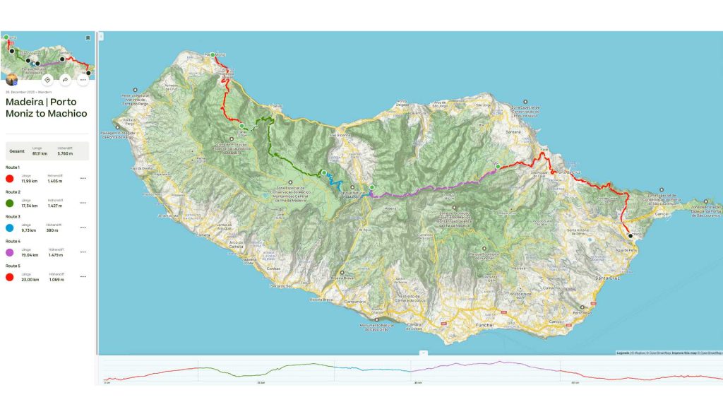
| Length | 51 miles (81 km) | |
| Starting point | Porto Moniz, Madeira | |
| End point | Machico, Madeira | |
| Highest point | Pico Ruivo, 6109 ft (1862m) | |
| Lowest point | Porto Moniz, near sea level at 42 ft (13 m) | |
| Ascent | Varies (total ascent is approximately 18,927 feet or 5.769 meters)* | |
| Descent | Varies (total descent is approximately 18,927 feet or 5.769 meters)* | |
| Stages | Typically divided into 5 major section | |
| Parque groups | Parque Ecologico de Funchal, Parque Natural da Madeira, Zona Especial de Consevacao do Macico | |
| Marking | The official hiking trails are marked as PR trails | |
| Circular route | No | |
| Both directions | yes | |
| Drinking water | Available at various points, but often sparse; water treatment is necessary | |
| Overnight stay | wild camping is generally not allowed, and overnight stays with a tent are restricted to designated camping sites or areas with permission. |
*Please note: The total ascent and descent are cumulative estimates and can vary depending on the exact path taken, as the trail can have numerous alternate routes and potential detours.
Best season for the tour
Spring (April to June) and fall (September to November) are usually the best times to go on tours in Madeira. The weather is warm, there aren’t as many people on the island, and nature is in full bloom during these months, making it a great time to hike and see the sights. Summer can also be nice, but there are more people then.
Tour description
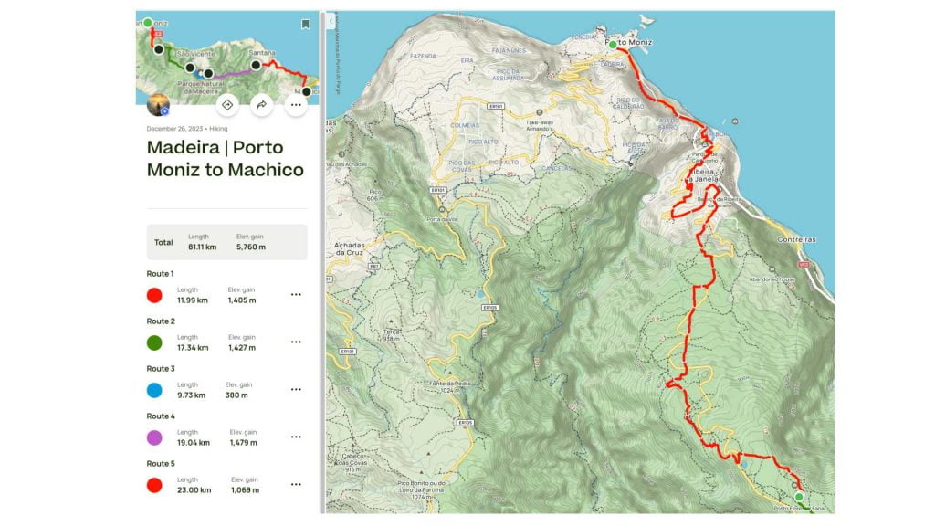
Day 1 | Porto Moniz – Fanal (Camping)
An area that is covered by Madeira’s native forest and is in a state of luxuriant development and development is where the Fanal camping area may be found. A member of the European Community Importance Network of Sites – Natura 2000 network, the Laurissilva forest has been designated as a World Natural Heritage Site by the United Nations Educational, Scientific, and Cultural Organization (UNESCO) since December 1999.
- Get my diary of the trip with all important details
- How to get a camping license for Madeira?
- What was my gear list for this trip on Madeira?
- Download the GPX Track for this trip on Madeira
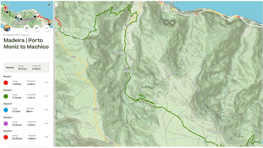
Day 2 | Fanal – Caramujio (Camping)
Paúl da Serra is the location of the camping area known as “Casa do Caramujo,” which is situated approximately 2.2 kilometers away from Bica da Cana. This is one of the most remote camping spots in Madeira, and it is completely surrounded by the native forest. The mountain home known as “Casa do Caramujo” is a house that has been abandoned. There was a possibility that in the past, it was a holiday home that was utilized by a few wealthy families. It is still possible to find a winter pond in the vicinity of the “Casa do Caramujo.” You have the option of taking the route that is recommended for PR. 17 – Caminho do Pináculo e Folhadal in order to access the camp area. Alternatively, you can utilize the ground struck dirt road that connects the Paul da Serra to the area of Sour cherries in St. Vincent.
This is also one of the few camping places that does not have a fireplace, making it a unique feature. The sole method of cooking that will be available is to make use of the gas burner. Although there is no running water, there are a number of waterfalls in the vicinity where you can make use of water to replenish your supply. It is imperative that you collect all of the garbage that was generated. Leave nothing behind, except for your footprints and the memories you have of your journey.
- Get my diary of the trip with all important details
- How to get a camping license for Madeira?
- What was my gear list for this trip on Madeira?
- Download the GPX Track for this trip on Madeira
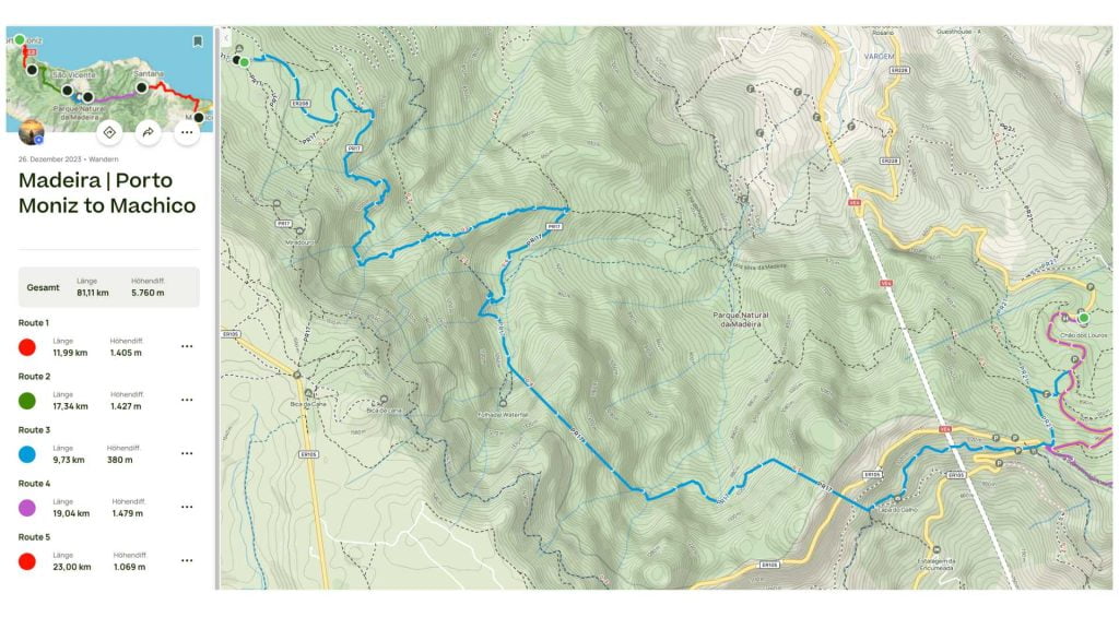
Day 3 | Caramujo – Chão dos Louros (Camping)
Located within the “Chão dos Louros” Forest Park is where you will find the designated camping area for the “Chão dos Louros” In São Vicente, this park is situated in close proximity to the regional road ER 228 that serves as a connection between the Encumeada and the Rosário. The name comes from the abundance of laurels, also known as Laurus nobilis, that can be found in this region.
In Madeira, there are a few fires where you may cook and prepare the well-known “espetada” using laurel sticks, as the Portuguese tradition requires. You will discover a central fireplace with a shelter in addition to the fireplaces that are dispersed throughout the park. This fireplace is perfect for holding a gathering or chatting around the fire on days when the temperature is low. Water is available from the tap at a number of different locations throughout the park. Maintain a prudent use of water and do not squander any of it. There is a recycling center located at the entrance, where you can segregate the rubbish that you bring in. Toiles are also available near the eastern end of the Park, so you can count on them.
You can also go on a stroll along the pathways that are recommended for the PR-21 and PR-22, which is a circular route that covers 1.9 kilometers and travels through the forest park’s surrounding area.
- Get my diary of the trip with all important details
- How to get a camping license for Madeira?
- What was my gear list for this trip on Madeira?
- Download the GPX Track for this trip on Madeira
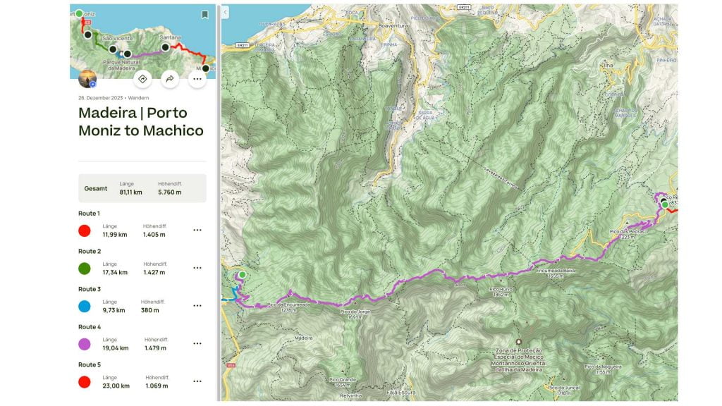
Day 4 | Chão dos Louros to Pico des Pedras (Camping)
The Pico das Pedras camping area may be found in the “Pico das Pedras” Forest Park in Laurissilva, which is situated at an elevation of around 910 meters. Laurissilva was chosen as the location of the park because it is situated in a transition zone between the exotic forest and the native forest of Madeira. A picnic area, restrooms, and parking for automobiles are all available at the woodland park. This park is designed to accommodate individuals who have physical or visual impairments, so enabling them to have direct interaction with the natural environment. The beginning of an important path route known as “A path for everyone” can be found in this area. This path route is accessible to people of all ages, including those who have some kind of motor or visual disability. Walking along the path takes around forty-five minutes. The term “Biosphere Reserve” refers to this particular region. In June of 2011, the United Nations Educational, Scientific, and Cultural Organization (UNESCO) recognised the richness of an ecosystem that tries to combine the conservation of biodiversity and the sustainable use of that biodiversity.
- Get my diary of the trip with all important details
- How to get a camping license for Madeira?
- What was my gear list for this trip on Madeira?
- Download the GPX Track for this trip on Madeira
Day 5 | Pico des Pedras to Machico
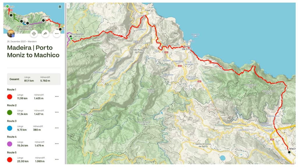
As you make your way from Porto da Cruz to Machico in Madeira, you will be surrounded by breathtaking vistas of the Atlantic Ocean throughout the entire journey. The road along the coast travels along the rough shoreline, revealing hidden coves and the captivating hues of the huge ocean. The aroma of the sea air and the sound of waves smashing against the rocks stimulate each and every stride that an individual takes. Porto da Cruz, with its quaint alleys and friendly residents, serves as a gorgeous starting point. On the other hand, the approach to Machico reveals a picturesque bay, which promises a tranquil conclusion to a thrilling climb.
- Get my diary of the trip with all important details
- How to get a camping license for Madeira?
- What was my gear list for this trip on Madeira?
- Download the GPX Track for this trip on Madeira
Extra Day | Visit Ponta de São Lourenço
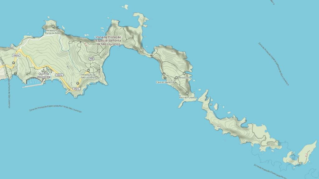
When I made the decision to book a tiny apartment in Santa Cruz, close to the airport, I were able to take advantage of the ideal opportunity to extend our journey to Ponta de São Lourenço by one day. On Madeira, the excursion location that is well-known and very popular is the climb that leads to Ponta de São Lourenço mountain. On your excursion, you will very certainly be joined by a large number of hikers, particularly if the weather is favorable. On the other hand, all of the people are dispersed throughout the path, which ensures that it is never very crowded.
For the approximately 8 kilometer hiking route, you should plan on spending approximately four hours on it, depending on the length of your breaks. Starting from the parking area for trekking at the Baía d’Abra viewpoint, you begin your journey. Within the next fifteen to twenty minutes, you will come to a crossroads. Turn right downhill to reach a stunning pebble beach that is completely secluded. If you go there early in the morning, you won’t come across very many other hikers. On the journey to Ponta de São Lourenço, there are various locations where one can have a picnic. Due to the fact that there is no provision for food and water on the hiking trail, you should make sure to bring your own. Not even toilets would do!
The Cais do Sardinha, a mansion that was constructed in 1905 and is now the location of the administration of the natural park, will be reached after around three kilometers. The Praia das Sardinhas stone beach, which is situated in a small bay and features bathing facilities, may be reached by foot from there. Alternatively, you can climb to the highest point of Ponta de São Lourenço, which is 176 meters high.
- Get my diary of the trip with all important details
- How to get a camping license for Madeira?
- What was my gear list for this trip on Madeira?
- Download the GPX Track for this trip on Madeira
Santa Cruz to Ponta de São Lourenço (via bus)
For the most up-to-date information on how to take the bus from Santa Cruz to Ponta de São Lourenço, you should check with the regional bus lines in Madeira. Rodoeste is usually the main bus company in the area. You can get the most up-to-date information on routes, times, and prices by visiting their website or calling them. This will help you plan your trip to Ponta de São Lourenço.
The best way to get from Santa Cruz to Ponta de São Lourenço without a car is to bus via Santa Cruz which takes 40m and costs €5.
Find Transport- Get my diary of the trip with all important details
- How to get a camping license for Madeira?
- What was my gear list for this trip on Madeira?
- Download the GPX Track for this trip on Madeira
GPX Track
Get my GPX Track
Are you preparing for a remarkable journey across Madeira’s stunning landscapes? Having up-to-date and accurate information is crucial! For all enthusiastic hikers and Madeira trail explorers, there’s an invaluable collection of resources – directly from me!
Madeira GPX Track

Leave a reply